Trail runners and mountain bikers from West Michigan are usually familiar with the Main Loop of Cannonsburg State Game Area (CSGA). Since I started running trail the CSGA has been a favorite of mine. At first my interest in this trail system was due to its proximity since I could get there in about 5 minutes. Over time the rolling hills, switchbacks, and beautiful nature has grown on me. You can find more information about CSGA, along with GPX files and turn by turn directions for my favorite routes on the CSGA trail page.
As you gain familiarity with the 7.5 miles that comprises the Main Loop you will soon begin to notice there appear to be a number of trails that are barely visible exiting and entering from one of the 4 primary sections. When I was talking with other trail runners during the weekly trail runs put on by the West Michigan Trail Runners group I was told of the Pirate Trail, Coke Machine Route, and the Inside Loop. Although finding theses trail systems proved next to impossible online and was equally as difficult trying to spot them while out of the trail. The best trail map that I had found to date is the one published by the WMBA, which unfortunately only shows the Main Loop.
After a numerous of runs and a lot of GPX editing I have mapped over 23.4 miles of trail in the game area. Some of these trails were easy to follow, some very difficult to find, and at least one was a bearing towards the Main Loop with no trail at all. In this 8 part blog post hopefully you will find an interesting account of my mapping experience as well as a detailed multi-track GPX file that allows you to explore and enjoy all of these trails without hesitation.
The Inside Loop
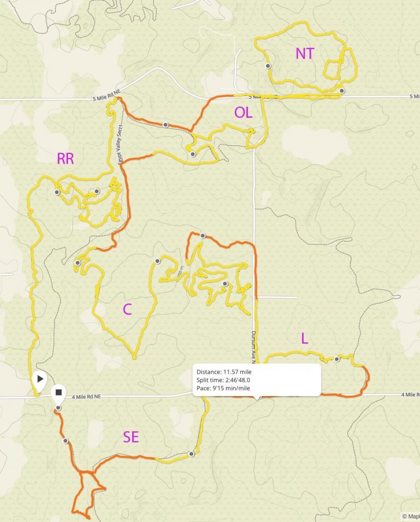
Earlier last year Dan, Brad, and I went for a run at CSGA where Dan showed us the Inside Loop which was a nice reprieve from the Main Loop. The Inside Loop and the Main Loop are mapped to the right, you can follow along the path we ran by scrolling your mouse along the elevation graph. There are quite a few forks and alternate paths throughout the Inside Loop but Dan knew the way and got us from end to end without issue. Luckily I have a pretty good image based memory and made a point to soak in some mental pictures at each turn. I ran this route many times in 2016 and started to wonder where all of the forks and alternate paths lead to; perhaps one of these was the Coke Machine Route, the Pirate Trail, or something different all together.
Sometime around mid-2016 Julian posted a route on Facebook which included:
- The Pirate Trail
- The Pirate Trail Alternate Loop (RR)
- Alternate Exit to Hyser Lake
- The Upper Loop (NT)
- Section 1 Outer Loop (OL)
- The Coke Machine Route (C)
- A portion of the Inside Loop
- A connector from south Dursam Ave parking lot to Section 2 (L)
- South East Loop in Section 4 (SE)
Unfortunately at the time the best I could do is capture a screenshot of this route and didn’t have the GPX file to help guide me through these various trail systems. However, my interest in discovering these routes was definitely increasing.
Be sure to check out CSGA Cartography – Part 2.