CSGA Cartography – Part 8

Be sure be sure to read CSGA Cartography – Part 7.

Completing the Cartography

When I started the effort to discover each and every trail segment I hadn’t put a lot of thought into how I would manifest those different runs into a single map.  Leading up to all of my ultra runs I spend a bit of time doing discovery and prep work; I read race reports, I scour Strava for clean GPX files of the race course, and I make spread sheets with laps, splits, aid stations, and historical data.   When I was preparing for the Black Canyon 100k I had come across a number of Strava efforts and their GPX files but wanted to clean up some of the faulty parts, segment the runs by aid station, and get a better understanding of the course layout. I found GPX Editor for Mac OSX which helped with editing, segmenting, and cleaning up GPX files.

To build out the full CSGA map, I followed this process:

  • Run a new or existing segment w/ a GPS watch, preferably on a clear day.
  • Export the GPX file after syncing with Strava
  • Import the track into the existing GPX file for all of CSGA
  • Trim the new track to only include the new or replacement segments
  • Delete any duplicate tracks I was replacing with new data
  • Name and number the segments something meaningful

I also spent the time to break every tracks up so that no track crosses another.  That means small connectors and segments between other trails end up being individual tracks.  The purpose for this is to allow anyone to create fully runnable routes in any order and any direction.  GPX Editor allows you to combine tracks, reverse the track order, and delete tracks so with this file you and fully customize any route you’d like through CSGA.  I will be creating a separate blog post that covers exactly how to work w/ GPX Editor to create comprehensive GPX files and maps like these.

Here is a full size screenshot of the CSGA map with the Main Loop highlighted in green for context, the GPX file of the complete CSGA trail system with all individual tracks can be downloaded here:

Here is a labeled map of Julian’s loop from CSGA Cartography – Part 1 highlighted in green side by side with his original. This followed by a GPS route for the loop.

CSGA Cartography – Part 7

CSGA Cartography – Part 7

Be sure be sure to read CSGA Cartography – Part 6.

Filling the Gaps

After finishing up the remainder of the Upper Loop from the end of CSGA Cartography – Part 6 I had made my way back to Section 1 where I took the first right (north) turn after just entering the trail to run the Section 1 Outer Loop (OL).  This trail starts with a fairly steep climb when you get to what appears to be the top there is a very short loop to the north east that continues uphill.  The main trail heads west back down the hill and runs parallel with Section 1.  There was a massive tree fallen at the bottom of the small valley which makes finding the trail difficult.  I ended up walking for about 5 minutes until I found the trail which was west and slightly north of where I had run into the downed tree.  The trail continues uphill and then back down and reconnects with the portion of Section 1 that cuts out the “old Section 1 loop”.

As I came to the 5 Mile Rd connector on Section 1 running counter clockwise I decided to finish the remainder of my long run by connecting Cannonsburg Ski Area which recently had opened to runners and mountain bikers.  The Ski Area trail is accessible via Egypt Valley Rd and the road section between the two is about 0.75 miles.

The remainder of the extra trails are off of Section 3 and 4 which I mapped over a number of runs.  The public maps show a “Bonus Section” that connects Section 4 back to 4 Mile Rd east of the main parking lot.  I ran this at the very end of a long run in late-March and running it at the end turned out to be quite the quad burner because it’s quite an up hill when running it counter clockwise.  I connected to this trail by running Section 4 counter clockwise in reverse.  As you come down the trail after 0.3 miles you’ll see a trail to the left that connects the bonus section.  Be prepared for a long up hill that eventually flattens out and exists you on 4 Mile Rd.

Just down from where the Bonus Section meets Section 4 when running counter clockwise you’ll find another trail to the left (north) that connections Section 4 to Section 3 without going out onto 3 Mile Rd.  The entrance from both sections are hard to spot but once you’ve run them the trails tend to be more noticeable.  I ran this section going from Section 4 to Section 3, when coming to the mid point you’ll come to a field and need to keep running east across the field to connect with the trail section that meets up with Section 3.  The next week I would run this same section in reverse (unfortunately I saved my run prematurely to take the picture below and it is split into two parts: here and here).

Read on for more trail details in CSGA Cartography – Part 8.

CSGA Cartography – Part 6

Be sure be sure to read CSGA Cartography – Part 5.

The Upper Loop

Following on from the Part 5 run where we finished the Pirate Trail mapping, Brad split off at end of the Pirate Trail where the trail meets the 5 Mile connector. He headed back down Section 1 running counter clockwise towards the main parking lot and  I went out the 5 Mile Rd connector and ran north east on 5 Mile Rd around Hyser Lake.  The stretch between the 5 Mile Rd connector and the Upper Loop parking lot is about 0.8 miles.  When I arrived I decided to take the first right turn at the cross section and stayed left shortly after.  The trail traverses up the side of the hill until you are at the top of the hill facing the main entrance from the parking lot where I took another right to continue on mapping out the trail.

I continued north and went east (right) at the first opportunity, this trail lead me to a house and private land where I doubled back turning back north (right) on the trail I had came from.  This trail went on for some time but I would eventually realize that much of this segment was likely private property despite me not seeing any markings; I wouldn’t recommend running the entire north portion of the run posted on Strava given much of this land is likely private, as a result, it is not included in the full map below.  As luck would have it I was a bit lost trying to find a way back via new trails when it started to rain and hail.  At least I had some foresight before leaving the house to wear a rain jacket which helped some but in this kind of down pour you’re getting wet.  I finally found my way back to the Upper Loop trail head and decided to bail out and head back to the CSGA main parking lot via Section 1 of the Main Loop.

Later that same week I set out for my weekend long run where I planned to map the remainder of the Upper Loop.  The day was sunny and in the high 40’s and would transition to the mid 50’s by the end of my run.  I started out on Section 1 and planned to take a trail that heads west about 0.5 miles into Section 1 at the top of the first climb.  This trail connected me back to the Pirate Trail which I completed and returned to Section 1 of the Main Loop at the 5 Mile Rd connector.  I ran the trail that connects north to Hyser Lake to get a better GPS track and then made my way up 5 Mile Rd to the Upper Loop.

This time I would go west at the first cross section after the parking lot.  You can see some of that trail system when running up 5 Mile Rd so I had some idea of where this trail would lead.  The trail here is single track, easy to follow, and loops back around.  Be careful here when you come to the top of the loop not to take the wide trail to the north or the trail to the east since they lead to private land.  I ended up taking what appeared to be an old two track south through the middle of the loop.  At first this trail was a wide two track which transitioned to clear single track and eventually into a difficult to see foot path.  This trail eventually drops out at the bottom of the outer loop just after you would go west of the cross section when entering the Upper Loop.  I ran back to the cross section towards the beginning and kept running east (a right turn when coming from the parking lot).  This segment leads though an open field section and drops off near some private land on the same trail I had run a few days prior.  Heading west up the hill reconnects you with the outer loop.

Read on for more trail details in CSGA Cartography – Part 7.

CSGA Cartography – Part 5

Be sure be sure to read CSGA Cartography – Part 4.

Pirate Completion and the Coke Machine Route

Despite numerous runs and GPS file editing there was still more work to do. I was missing the the Pirate Trail Alternate Loop (RR), the Coke Machine Route (C), the connector from south Dursam Ave parking lot to Section 2 (L), the South East Loop in Section 4 (SE), as well as a solid mapping of the Upper Loop (NT).  I would eventually run each of these in full over two weeks in late March and April 2017.

My first attempt to capture the Pirate Trail Alternate Loop (RR) started with the standard difficulty of finding the entrance of 4 Mile Rd. After I settled in I knew that the Alternate Loop started just after a passing through an uphill cross section where after coming downhill you hit a 4-way fork where you typically go left; this is about 1.0 miles into the Pirate Trail.  Instead of going left you continue straight into the Alternate Loop.  The trail in the early spring is pretty difficult to keep track of in some spots.  When I lost the indent of the trail I would spend a little bit of time walking nearby and would find the trail again.  About 0.6 miles into this trail I went up a short up hill, crossed a wooden bridge and found myself back on Section 1.  It seems that I ran only about half of the Alternate Loop, the remainder which should have cut north prior to the wooden bridge was not obvious.

Back on Section 1 I was running counter clockwise and entered the Inside Loop with the intent to find the Coke Machine Route (C) that Julian had mapped the summer prior.  I had been combining and touching up my GPS routes that I had run at CSGA using GPX Editor for Mac and felt that I knew exactly where to turn to find enter the that trail segment.  After running the initial set of switchbacks on the Inside Loop, about 0.5 miles in, I took the trail to the right heading southeast to enter the Coke Machine Route.  This route heads southeast until you come out to a sandy open area where you’ll find an abandoned rusted out CocaCola machine and promptly reenter the woods heading to the north east.  The Coke Machine Route (C) ends with a set of right turns which brought me back onto the Inside Loop running in a clockwise direction.

Exiting the Inside Loop via the Dursam Ave parking lot I headed to the south towards the southern parking lot which is on the opposite side of the road in an attempt to find the connector from south Dursam Ave parking lot to Section 2 (L).  The beginning of the this trail starts from the parking lot and is a fairly obvious and wide single track.  The obviousness ends about 0.3 miles into the trail on a quick downhill that brought me to a pond where I promptly lost the trail.  I would on a later run press through the woods heading towards Section 2 of the Main Loop despite being unable to locate a trail; this is one of the only segments that I mapped where no trail seemed to exist.

On a later run with Brad he helped me complete the remainder of the Pirate Trail Alternate Loop (RR)  to the north east.  We entered the loop about 1.1 miles into Section 1 of the Main Loop, crossed the wooden bridge and began searching for the trail.  The trail here headed back towards the pond, traverses the ravine a number of times, and eventually heads back around the pond.  There are a few odd switchbacks that are fairly tight on this section of the loop so we spent a bit of time searching for the trail when we lost sight of it.  This loop ends back where it began about 3 or 4 paces past the 4-way cross section of the Pirate Trail.

Read on for more trail details in CSGA Cartography – Part 6.

CSGA Cartography – Part 4

CSGA Cartography – Part 4

Be sure be sure to read CSGA Cartography – Part 3.

Long Run Cartography

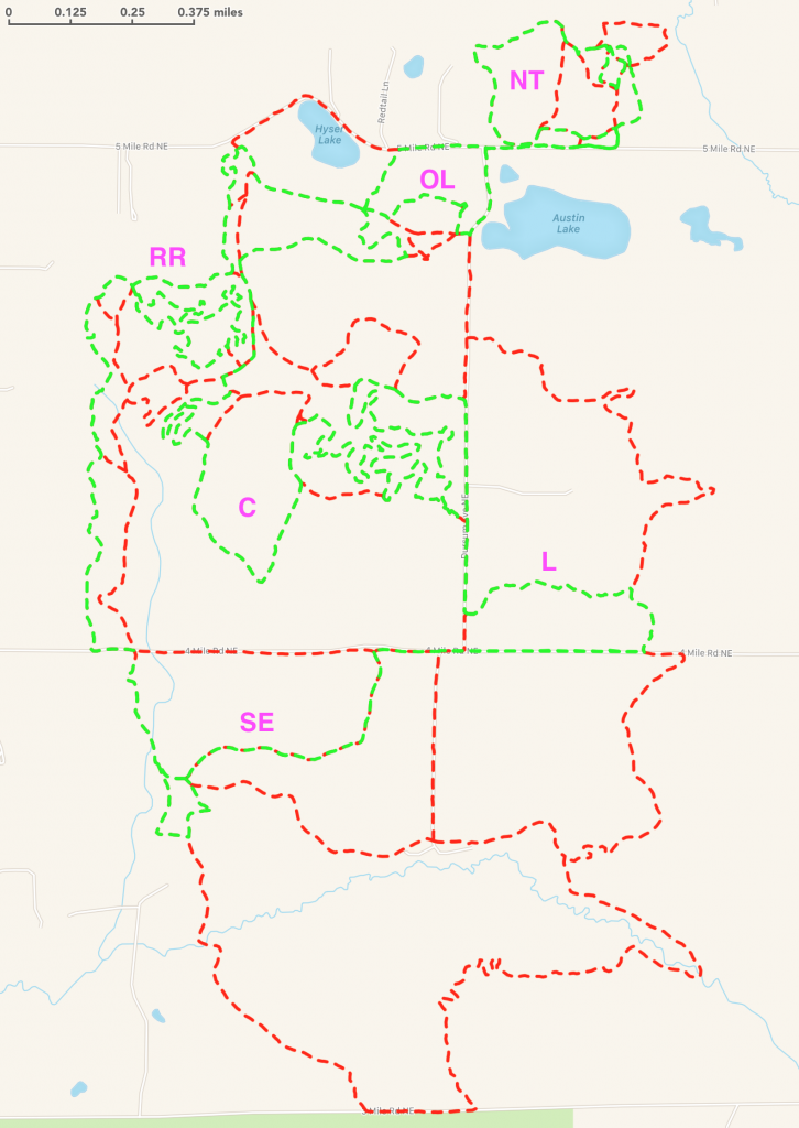
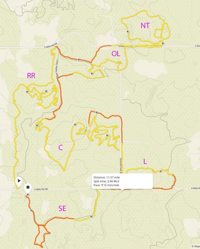
I can’t think of a better way to map out trails than on a long run, and on this mid-March run I was set out to get a better GPS track for the Pirate Trail, Inside Loop, and explore whatever trails I could when I looped back around.  The thinking was to run the trails as I knew them, plotting a solid course, and using the map on Garmin Fenix 3 when I was exploring the forks and trails that extend out from the primary single track.  This approach helped me keep a bearing and perspective on where I was relative to the trails I had just run.

The Pirate Trail still is as hard as ever to find when coming from 4 Mile Rd I usually run past it, double back, and then finally catch a small cut in the woods where you enter; today was no different.  After getting back on the trail I ran north, crossing the creek, then coming to a set of massive trees that were down.  With the downed trees I had lost the trail and had to spend some time climbing trees and searching for the trail which I later found just west of me.

Eventually on the Pirate Trail you come up on a brown house to the west that is fairly close to the trail, you’ll see some trails west of the Pirate Trail but they are all private.  Shortly after you pass that house, maybe 0.1 mile, there is a fork in the trail that is barely noticeable to the left.  If you stay right it brings you back out onto Section 1 of the Main Loop and going left will keep you on the Pirate Trail.  On this run I still couldn’t get this fork down and found myself standing on Section 1 and realizing that I needed to turn around to get back to the Pirate Trail. The remainder of the Pirate Trail was pretty easy to follow and it ends at the 5 Mile Rd connector about 1.5 Miles into Section 1 of the Main Loop.

After getting lost running the Inside Loop backwards the year before I was determined to give it another go on this run.  I headed out Section 1 to Dursam Ave and entered the Inside Loop from the parking lot.  The main trick with running the Inside Loop backwards is to take the first left about 0.2 mile up the trail, going straight and left later will cause you take the switchbacks in the direction that heads back to Dursam Ave.  After taking the first left the primary single track is pretty easy to follow by not taking any of the hard turns and going with the flow of the trail.  When I got back to Section 1 I went left (south) and headed back to the parking lot to refill water before starting a second loop.

Starting the second loop I once again went out the Pirate Trail, took the wrong fork which lead me to Section 1, and doubled back and completed the Pirate Trail.  I was back on Section 1 and decided to take the right turn towards the very end of Section 1 just prior to Dursam Ave.  I had inadvertently run this section of trail a month or so prior at night in a couple of feet of snow while trying to follow a set of cross country ski tracks.  During the day with no snow the single track was fairly easy to follow and lead back to the “old section 1” portion of the trail and continues straight west after a short stint on the main single track.  This trail is fairly wide and hilly and exists back down into a latter portion of Section 1.

At this point was heading counter clockwise on Section 1 of the main loop, as I came up to the field portion of Section 1 I couldn’t help but notice a trail to the left that heads slight southeast.  I took that trail and pulled up the map on my Garmin Fenix 3, realizing that this trail has a heading towards the Inside Loop.  This trail runs through a beautiful section of mostly open field and reconnects with Inside Loop at the same point where you turn to right to head towards the Dursam Ave parking lot if you are coming from Section 1 or where you would turn left if you were coming the opposite direction.

I took a sharp left and ran the initial set of switchbacks in a counter clockwise direction.  About 1.0 miles into the switchbacks I decided to take a trail to the left that headed southwest.  This trail cuts the remaining switchbacks inside of the Inner Loop and I would later find out that it also provides access to the Coke Machine Route.  At this point I was about 19.7 miles into a 20.0 mile run and already a few minutes late to get home due to my trail exploration efforts and I decided to blaze a trail directly back to Section 1 through the deep woods to cut out some distance and time; I would have to clean up that GPS portion of the run for the final map later.

Read on for more trail details in CSGA Cartography – Part 5.

CSGA Cartography – Part 3

Be sure be sure to read CSGA Cartography – Part 2.

The Inside Loop – Take 2

The hunting season was coming to a close in January, 2017 and I was pretty eager set out and discover these trails.  Late winter proved to be a great time for trail discovery especially following a light and wet snow which highlighted old and difficult to find paths that have long since been covered with leafs.  I spent some time searching the Internet for some guidance but beyond the WMBA map and the screen shot of Julian’s run there wasn’t much of anything.  The lack of trail information or maps for these less traveled segments had me excited to pull together a comprehensive map of every trail in the game area.  With the leafs off the trees the GPS tracks would be as good as they get so I set off to run every inch of every trail that I could find over the course of about a month and planned to stitch those runs into a multi-track GPX file.

In early March I had planned on running the 6 mile the Inner Loop, planning to take a left or right onto some of the trails I had seen but hadn’t yet traveled.   The weather was cold with a light wet snow which highlighted the less traveled trails quite well; this run would prove to be short and adventurous.  I ran the first 1 of Section 1 and took the right turn into the Inner Loop, given that I hadn’t run here since early fall I was mostly following the indent in the fresh snow not immediately recognizing the trails around me.  This approach led me straight down the hill after entering the Inner Loop and heading back up the switchbacks in reverse.  When I came back to the head of the switchbacks I realized my mistake and started back down the Inner Loop.

Coming down the trail I had the first opportunity to take a right turn off the Inner Loop onto a trail that I hadn’t yet run.  The single track was easy to follow but after encountering some fallen trees I lost the trail and decided to head back the way I came.  I would later find out this is section of the Inner Loop was the Coke Machine Trail which I’ll provide more info about later.  Heading back the way I came I reconnected with the Inner Loop and decided to go right and run the remainder of the loop.

As I was coming up the trail that leads to the Dursam Ave parking lot I spotted a trail to the left that headed north and took it.  The trail here went up hill and I was hoping it would connect back to Section 1.  Up the hill the single track ended without a sign in the wet snow as to which way to go.  I pulled the map up on my Garmin Fenix 3, got a bearing to the southwest, and headed through the woods without a sign of trail in front of me.  I eventually met back up with the Inside Loop and took that back to Section 1 heading back to the parking lot.  This run definitely highlighted that there are many trail options that intertwine the Inside Loop, knowing them well is key to not getting turned around or finding yourself at a premature dead end.

Read on for more trail details in CSGA Cartography – Part 4.

CSGA Cartography – Part 2

CSGA Cartography – Part 2

[/one_half_last]

Be sure be sure to read CSGA Cartography – Part 1.

Getting Lost on The Pirate Trail

In early September, 2016 I set out to find the Pirate Trail on a long run in the weeks leading up to the Woodstock 50 miler.  After running up and down 4 Mile Rd west of the main parking lot I saw a faint resemblance of a trail and stepped into the deep cover.  After a few paces the trail became slightly more distinguished but I realized quickly that this wasn’t going to be one of those set back and follow the trail types of runs, it was going to require getting lost, searching for the trail, and a good lock on my orientation.  Luckily my Garmin Fenix 3 has a mapping function that works during the run so at least I could tell where I had been and what my current heading was.

I found that the Pirate Trail has a number of offshoots many of which connect you to various spots on Section 1 of the main loop.  All of the trails to the west lead to private property and should be avoided.  After about 1.8 miles I found myself at the 5 Mile Rd connector which is about 1.5 miles up Section 1 on the Main Loop.  I started down 5 Mile Rd but decided to double back and see if I could find the Section 1 to Hyser Lake route.  I found that trail by continuing straight and passing the turn that takes you to the “old Section 1 loop”, the trail heads north east and comes down to the wood deck walk way.

The Upper Loop (NT) can be a bit confusing and instead of take the outer of the two loops I went straight ahead into the inner loop on top of the hill.  I got turned around and found myself back down at the parking lot and decided to head back towards Dursam Ave where I planned to run the Inner Loop backwards.  I found the trail head with ease but despite running the Inner Loop a number of times throughout the summer I had never run it backwards.  With the various off shot trails, two and three way forks, I quickly got turned around and was heading back up the familiar trail that leads to the Dursam Ave parking lot.  At this point I realized my 10 mile plan was going to be a bit longer.

As 2016 turned to fall CSGA becomes off limits to the mountain biking community to allow hunters to make the most of the small game and deer season in the game area.  I typically will not run at CSGA during the same period so my interest in discovering these new routes would have to wait until 2017.

Read on for more trail details in CSGA Cartography – Part 3.

CSGA Cartography – Part 1

CSGA Cartography – Part 1

Trail runners and mountain bikers from West Michigan are usually familiar with the Main Loop of Cannonsburg State Game Area (CSGA).  Since I started running trail the CSGA has been a favorite of mine.  At first my interest in this trail system was due to its proximity since I could get there in about 5 minutes.  Over time the rolling hills, switchbacks, and beautiful nature has grown on me.  You can find more information about CSGA, along with GPX files and turn by turn directions for my favorite routes on the CSGA trail page.

As you gain familiarity with the 7.5 miles that comprises the Main Loop you will soon begin to notice there appear to be a number of trails that are barely visible exiting and entering from one of the 4 primary sections.  When I was talking with other trail runners during the weekly trail runs put on by the West Michigan Trail Runners group I was told of the Pirate Trail, Coke Machine Route, and the Inside Loop.  Although finding theses trail systems proved next to impossible online and was equally as difficult trying to spot them while out of the trail.  The best trail map that I had found to date is the one published by the WMBA, which unfortunately only shows the Main Loop.

After a numerous of runs and a lot of GPX editing I have mapped over 23.4 miles of trail in the game area.  Some of these trails were easy to follow, some very difficult to find, and at least one was a bearing towards the Main Loop with no trail at all.  In this 8 part blog post hopefully you will find an interesting account of my mapping experience as well as a detailed multi-track GPX file that allows you to explore and enjoy all of these trails without hesitation.

The Inside Loop

Earlier last year Dan, Brad, and I went for a run at CSGA where Dan showed us the Inside Loop which was a nice reprieve from the Main Loop. The Inside Loop and the Main Loop are mapped to the right, you can follow along the path we ran by scrolling your mouse along the elevation graph.  There are quite a few forks and alternate paths throughout the Inside Loop but Dan knew the way and got us from end to end without issue.  Luckily I have a pretty good image based memory and made a point to soak in some mental pictures at each turn.  I ran this route many times in 2016 and started to wonder where all of the forks and alternate paths lead to; perhaps one of these was the Coke Machine Route, the Pirate Trail, or something different all together.

Sometime around mid-2016 Julian posted a route on Facebook which included:

  • The Pirate Trail
  • The Pirate Trail Alternate Loop (RR)
  • Alternate Exit to Hyser Lake
  • The Upper Loop (NT)
  • Section 1 Outer Loop (OL)
  • The Coke Machine Route (C)
  • A portion of the Inside Loop
  • A connector from south Dursam Ave parking lot to Section 2 (L)
  • South East Loop in Section 4 (SE)

Unfortunately at the time the best I could do is capture a screenshot of this route and didn’t have the GPX file to help guide me through these various trail systems.   However, my interest in discovering these routes was definitely increasing.

Be sure to check out CSGA Cartography – Part 2.